
Tai Tong Tsuen topographic map
Interactive map
Click on the map to display elevation.
About this map
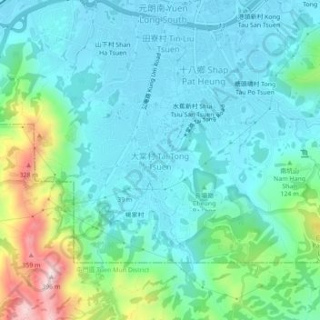
Name: Tai Tong Tsuen topographic map, elevation, terrain.
Average elevation: 272 ft
Minimum elevation: 7 ft
Maximum elevation: 1,234 ft
Other topographic maps
Click on a map to view its topography, its elevation and its terrain.
Full View of Shap Pat Heung
China > Hong Kong > Tai Tong Tsuen
Full View of Shap Pat Heung, Tai Tong Shan Road, Tai Tong Tsuen, Yuen Long District, New Territories, Hong Kong, China
Average elevation: 249 ft