
Ozhukarai Taluk topographic map
Interactive map
Click on the map to display elevation.
About this map
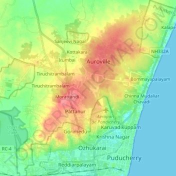
Name: Ozhukarai Taluk topographic map, elevation, terrain.
Location: Ozhukarai Taluk, Puducherry district, Puducherry, India (11.92058 79.76624 12.05098 79.87460)
Average elevation: 75 ft
Minimum elevation: 0 ft
Maximum elevation: 207 ft
Other topographic maps
Click on a map to view its topography, its elevation and its terrain.
Veerampattinam
India > Puducherry > Puducherry Taluk
Veerampattinam, Puducherry Taluk, Puducherry District, Puducherry, 605004, India
Average elevation: 10 ft
Puducherry
India > Puducherry > Puducherry Taluk
Puducherry, Puducherry Taluk, Puducherry District, Puducherry, 605001, India
Average elevation: 33 ft
Bahour Taluk
India > Puducherry > Bahour Taluk
Bahour Taluk, Puducherry district, Puducherry, India
Average elevation: 23 ft
Karaikal
India > Puducherry > Karaikal Taluk
Karaikal, Karaikal Taluk, Karaikal district, Puducherry, 609602, India
Average elevation: 10 ft
Oulgaret
India > Puducherry > Ozhukarai Taluk
Oulgaret, Ozhukarai Taluk, Puducherry District, Puducherry, 605005, India
Average elevation: 59 ft
Nedungadu
India > Puducherry > Nedungadu
Nedungadu, Thirunallar Taluk, Karaikal, Puducherry, India
Average elevation: 16 ft
Mahe
India > Puducherry > Mahe Taluk
Mahe, Mahe Taluk, Mahe district, Puducherry, 673310, India
Average elevation: 33 ft
Yanam
India > Puducherry > Yanam Taluk
Yanam, Yanam Taluk, Yanam District, Puducherry, 533464, India
Average elevation: 16 ft
Kalapet
India > Puducherry > Kalapet
Kalapet, Ozhukarai Taluk, Puducherry district, Puducherry, 605014, India
Average elevation: 46 ft