
Make a donation
Gear up for your next adventure:
As an Amazon Associate, this site earns from qualifying purchases at no extra cost to you.
Bhuj topographic map
Click on the map to display elevation.
Make a donation
Gear up for your next adventure:
As an Amazon Associate, this site earns from qualifying purchases at no extra cost to you.
Bhuj
Bhuj has an average elevation of 110 metres (360 feet). On the eastern side of the city is a hill known as Bhujia Hill, on which there is a Bhujia Fort, that separates Bhuj city and Madhapar town ( considered one of the richest villages in Asia ). It has two lakes namely Hamirsar and Deshadsar (દેેેશળસર).
Make a donation
Gear up for your next adventure:
As an Amazon Associate, this site earns from qualifying purchases at no extra cost to you.
About this map
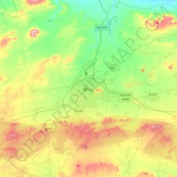
Name: Bhuj topographic map, elevation, terrain.
Location: Bhuj, Bhuj Taluka, Kachchh, Gujarat, 370001, India (23.08724 69.50834 23.40724 69.82834)
Average elevation: 427 ft
Minimum elevation: 33 ft
Maximum elevation: 1,102 ft
Make a donation
Gear up for your next adventure:
As an Amazon Associate, this site earns from qualifying purchases at no extra cost to you.