
Loustal Nau topographic map
Interactive map
Click on the map to display elevation.
About this map
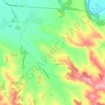
Name: Loustal Nau topographic map, elevation, terrain.
Average elevation: 627 ft
Minimum elevation: 407 ft
Maximum elevation: 912 ft
Other topographic maps
Click on a map to view its topography, its elevation and its terrain.
En Cabrol
France > Occitanie > Tarn > Massac-Séran
En Cabrol, Massac-Séran, Castres, Tarn, Occitanie, France métropolitaine, 81500, France
Average elevation: 617 ft
La Rendie
France > Occitanie > Tarn > Massac-Séran
La Rendie, Massac-Séran, Castres, Tarn, Occitanie, France métropolitaine, 81500, France
Average elevation: 627 ft