
Make a donation
Gear up for your next adventure:
As an Amazon Associate, this site earns from qualifying purchases at no extra cost to you.
Ellicott City topographic map
Click on the map to display elevation.
Make a donation
Gear up for your next adventure:
As an Amazon Associate, this site earns from qualifying purchases at no extra cost to you.
About this map
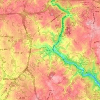
Name: Ellicott City topographic map, elevation, terrain.
Location: Ellicott City, Howard County, Maryland, 21043, United States (39.22733 -76.83831 39.30733 -76.75831)
Average elevation: 390 ft
Minimum elevation: 52 ft
Maximum elevation: 558 ft
Howard County trails, hiking, mountain biking, running and outdoor activities
Make a donation
Gear up for your next adventure:
As an Amazon Associate, this site earns from qualifying purchases at no extra cost to you.
Other topographic maps
Click on a map to view its topography, its elevation and its terrain.
Patapsco Valley State Park
United States > Maryland > Howard County > Ilchester
Average elevation: 430 ft