
Folgoso do Courel topographic map
Interactive map
Click on the map to display elevation.
About this map
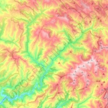
Name: Folgoso do Courel topographic map, elevation, terrain.
Location: Folgoso do Courel, Quiroga, Lugo, Galicia, Spain (42.52418 -7.29724 42.70849 -7.03353)
Average elevation: 3,130 ft
Minimum elevation: 1,066 ft
Maximum elevation: 5,358 ft
Other topographic maps
Click on a map to view its topography, its elevation and its terrain.
Seceda
Spain > Galicia > Quiroga > Folgoso do Courel
Seceda, Folgoso do Courel, Quiroga, Lugo, Galicia, Spain
Average elevation: 2,989 ft
Folgoso do Courel
Spain > Galicia > Quiroga > Folgoso do Courel > Folgoso do Courel
Folgoso do Courel, Quiroga, Lugo, Galicia, 27325, Spain
Average elevation: 2,516 ft