
Río Mosna topographic map
Interactive map
Click on the map to display elevation.
About this map
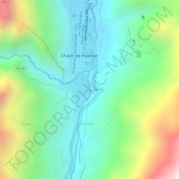
Name: Río Mosna topographic map, elevation, terrain.
Location: Río Mosna, Chavín de Huantar, Huari, Áncash, Perú (-9.59654 -77.17732 -9.59099 -77.17603)
Average elevation: 11,161 ft
Minimum elevation: 10,230 ft
Maximum elevation: 13,038 ft
Other topographic maps
Click on a map to view its topography, its elevation and its terrain.
Sitio Arqueológico de Chavín
Perú > Áncash > Chavín de Huantar > Cochas
Sitio Arqueológico de Chavín, Cochas, Chavín de Huantar, Huari, Áncash, Perú
Average elevation: 11,178 ft
Nunupata
Perú > Áncash > Chavín de Huantar > Nunupata
Nunupata, Chavín de Huantar, Provincia de Huari, Áncash, Perú
Average elevation: 12,113 ft
Cochas
Perú > Áncash > Chavín de Huantar > Cochas
Cochas, Chavín de Huantar, Provincia de Huari, Áncash, Perú
Average elevation: 11,722 ft