Geolocate
👉 Easily get elevation data in JSON, GeoTIFF and KML formats using Elevation API
Thank you for supporting this site ❤️
Make a donation

Tali topographic map

Click on the map to display elevation.

👉 Easily get elevation data in JSON, GeoTIFF and KML formats using Elevation API
Thank you for supporting this site ❤️
Make a donation

About this map

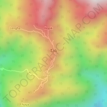
Name: Tali topographic map, elevation, terrain.

Location: Tali, Tali ADC, Kra Daadi, Arunachal Pradesh, India (28.01662 93.75003 28.02362 93.75314)

Average elevation: 3,615 ft

Minimum elevation: 1,768 ft

Maximum elevation: 5,285 ft

Gear up for your next adventure:

📷Action Camera - Capture your outdoor adventures in HD
📶Satellite Messenger - Communication device off‑grid
🧦Merino Wool Socks - Moisture-wicking, blister-preventing socks for long treks
🎒Trail Energy Bars - High‑calorie bars for hiking energy
🧴Hand Sanitizer - Keep hands clean while hiking

As an Amazon Associate, this site earns from qualifying purchases at no extra cost to you.