
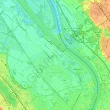
Village-Neuf topographic map
Interactive map
Click on the map to display elevation.
About this map
Name: Village-Neuf topographic map, elevation, terrain.
Average elevation: 814 ft
Minimum elevation: 761 ft
Maximum elevation: 892 ft
Other topographic maps
Click on a map to view its topography, its elevation and its terrain.
Pulvermuehle
France > Grand Est > Haut-Rhin > Volgelsheim
Pulvermuehle, Volgelsheim, Colmar-Ribeauvillé, Haut-Rhin, Grand Est, France métropolitaine, 68600, France
Average elevation: 630 ft
Les Basses Huttes
France > Grand Est > Haut-Rhin > Orbey
Les Basses Huttes, Orbey, Colmar-Ribeauvillé, Haut-Rhin, Grand Est, France métropolitaine, 68370, France
Average elevation: 2,654 ft
Kaysersberg
France > Grand Est > Haut-Rhin > Kaysersberg-Vignoble
Kaysersberg, Kaysersberg-Vignoble, Colmar-Ribeauvillé, Haut-Rhin, Grand Est, France métropolitaine, 68240, France
Average elevation: 1,716 ft
Michelbach
France > Grand Est > Haut-Rhin > Aspach-Michelbach
Michelbach, Aspach-Michelbach, Thann-Guebwiller, Haut-Rhin, Grand Est, France métropolitaine, 68700, France
Average elevation: 1,109 ft