
Karaabdülbaki topographic map
Interactive map
Click on the map to display elevation.
About this map
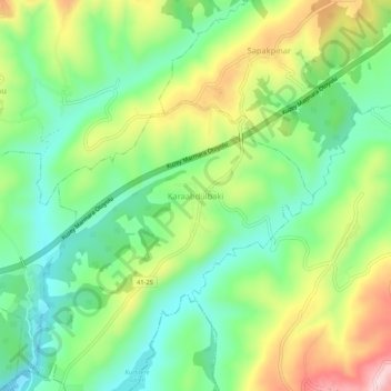
Name: Karaabdülbaki topographic map, elevation, terrain.
Location: Karaabdülbaki, İzmit, Kocaeli, Marmara Region, Turkey (40.77739 30.13429 40.81739 30.17429)
Average elevation: 551 ft
Minimum elevation: 194 ft
Maximum elevation: 1,145 ft
Other topographic maps
Click on a map to view its topography, its elevation and its terrain.
Alikahya Fatih Mahallesi
Alikahya Fatih Mahallesi, İzmit, Kocaeli, Marmara Region, 41000, Turkey
Average elevation: 102 ft