
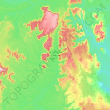
Chiribiquete (Macizo Central) topographic map
Interactive map
Click on the map to display elevation.
About this map
Name: Chiribiquete (Macizo Central) topographic map, elevation, terrain.
Location: Chiribiquete (Macizo Central), Solano, Caquetá, Colombia (0.38732 -72.96391 0.79344 -72.67372)
Average elevation: 951 ft
Minimum elevation: 505 ft
Maximum elevation: 1,929 ft
Chiribiquete National Park is situated in the western region of the Guiana Shield, east of the Eastern Cordillera, north of the Amazonian plains, west of the Upper Río Negro, and south of the savannas of the Orinoquía. Elevations in the park range from about 200 to 1,000 metres above sea level. It contains geological formations that are made up of plateaus and steep rocky structures. The formations are divided into three different sections: the Northern Massif, the Central Massif and Iguaje Messas. The park is well known for its tepuis, table-top mountains that abruptly rise from the forest. The mountain ridge of Chiribiquete is an important remnant of the rocky chain belonging to the Precambrian and Paleozoic formations that make up the Guiana Shield.