
Thronos topographic map
Interactive map
Click on the map to display elevation.
About this map
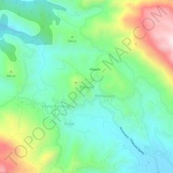
Name: Thronos topographic map, elevation, terrain.
Average elevation: 1,729 ft
Minimum elevation: 1,050 ft
Maximum elevation: 3,258 ft
Other topographic maps
Click on a map to view its topography, its elevation and its terrain.
Plakias
Griechenland > Region Kreta > Regionalbezirk Rethymno
Plakias, Provinz Agios Vasilios, Regionalbezirk Rethymno, Region Kreta, 740 60, Griechenland
Average elevation: 404 ft
Rethymno
Griechenland > Region Kreta > Regionalbezirk Rethymno
Rethymno, Provinz Rethymnon, Regionalbezirk Rethymno, Region Kreta, 741 31, Griechenland
Average elevation: 669 ft
Atsipopoulo
Griechenland > Region Kreta > Regionalbezirk Rethymno > Atsipopoulo
Atsipopoulo, Provinz Rethymnon, Regionalbezirk Rethymno, Region Kreta, 74132, Griechenland
Average elevation: 469 ft