
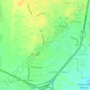
Cape Town Ward 106 topographic map
Interactive map
Click on the map to display elevation.
About this map
Name: Cape Town Ward 106 topographic map, elevation, terrain.
Average elevation: 148 ft
Minimum elevation: 102 ft
Maximum elevation: 200 ft
Other topographic maps
Click on a map to view its topography, its elevation and its terrain.
Europe
RSA > Cap occidental > Le Cap
Europe, Le Cap, City of Cape Town, Cap occidental, 7490, RSA
Average elevation: 118 ft
Table Mountain
RSA > Cap occidental > Le Cap
Table Mountain, Fountain Ledges, Cape Town Ward 77, Le Cap, City of Cape Town, Cap occidental, 8005, RSA
Average elevation: 1,913 ft
False Bay
RSA > Cap occidental > Le Cap
False Bay, Le Cap, City of Cape Town, Cap occidental, RSA
Average elevation: 0 ft
Table Bay Nature Reserve
RSA > Cap occidental > Le Cap
Table Bay Nature Reserve, Malgas Road, Cape Town Ward 113, Le Cap, City of Cape Town, Cap occidental, 7441, RSA
Average elevation: 33 ft