
Make a donation
Gear up for your next adventure:
As an Amazon Associate, this site earns from qualifying purchases at no extra cost to you.
Tangier topographic map
Click on the map to display elevation.
Make a donation
Gear up for your next adventure:
As an Amazon Associate, this site earns from qualifying purchases at no extra cost to you.
Tangier
Tangier was formally known as Colonia Julia Tingi ("The Julian Colony of Tingis") following its elevation to colony status during the Roman Empire. The nicknames "Bride of the North" and "Door of Africa" reference its position in far northwestern Africa near the Strait of Gibraltar.
Make a donation
Gear up for your next adventure:
As an Amazon Associate, this site earns from qualifying purchases at no extra cost to you.
About this map
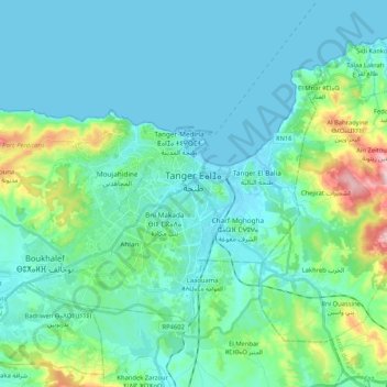
Name: Tangier topographic map, elevation, terrain.
Average elevation: 223 ft
Minimum elevation: -3 ft
Maximum elevation: 1,562 ft
Make a donation
Gear up for your next adventure:
As an Amazon Associate, this site earns from qualifying purchases at no extra cost to you.
Other topographic maps
Click on a map to view its topography, its elevation and its terrain.
Dar Barroud
Morocco > Tangier-Tetouan-Al Hoceima > Pachalik de Tanger باشوية طنجة > Tangier
Average elevation: 66 ft
Rmilet
Morocco > Tangier-Tetouan-Al Hoceima > Pachalik de Tanger باشوية طنجة > Tanger طنجة
Average elevation: 367 ft
Parque del Marxán
Morocco > Tangier-Tetouan-Al Hoceima > Pachalik de Tanger باشوية طنجة > Tangier
Average elevation: 95 ft
Mghayer
Morocco > Tangier-Tetouan-Al Hoceima > Pachalik de Tanger باشوية طنجة > Tangier
Average elevation: 305 ft
Make a donation
Gear up for your next adventure:
As an Amazon Associate, this site earns from qualifying purchases at no extra cost to you.