
Ettersberg topographic map
Interactive map
Click on the map to display elevation.
About this map
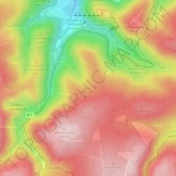
Name: Ettersberg topographic map, elevation, terrain.
Average elevation: 1,555 ft
Minimum elevation: 935 ft
Maximum elevation: 1,946 ft
Other topographic maps
Click on a map to view its topography, its elevation and its terrain.
Harlingerode
Deutschland > Niedersachsen > Landkreis Goslar > Bad Harzburg
Harlingerode, Bad Harzburg, Landkreis Goslar, Niedersachsen, Deutschland
Average elevation: 653 ft
Schlewecke
Deutschland > Niedersachsen > Landkreis Goslar > Bad Harzburg
Schlewecke, Bad Harzburg, Landkreis Goslar, Niedersachsen, Deutschland
Average elevation: 784 ft
Bündheim
Deutschland > Niedersachsen > Landkreis Goslar > Bad Harzburg
Bündheim, Bad Harzburg, Landkreis Goslar, Niedersachsen, 38667, Deutschland
Average elevation: 1,017 ft
Göttingerode
Deutschland > Niedersachsen > Landkreis Goslar > Bad Harzburg
Göttingerode, Bad Harzburg, Landkreis Goslar, Niedersachsen, Deutschland
Average elevation: 945 ft