
Make a donation
Gear up for your next adventure:
As an Amazon Associate, this site earns from qualifying purchases at no extra cost to you.
Jette topographic map
Click on the map to display elevation.
Make a donation
Gear up for your next adventure:
As an Amazon Associate, this site earns from qualifying purchases at no extra cost to you.
About this map
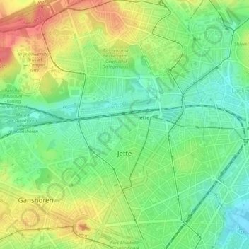
Name: Jette topographic map, elevation, terrain.
Location: Jette, Brussels-Capital, 1090, Belgium (50.86451 4.29376 50.89415 4.34067)
Average elevation: 148 ft
Minimum elevation: 56 ft
Maximum elevation: 266 ft
Make a donation
Gear up for your next adventure:
As an Amazon Associate, this site earns from qualifying purchases at no extra cost to you.
Other topographic maps
Click on a map to view its topography, its elevation and its terrain.
Roodebeek
Belgium > Brussels-Capital > Woluwe-Saint-Lambert - Sint-Lambrechts-Woluwe
Average elevation: 213 ft
Make a donation
Gear up for your next adventure:
As an Amazon Associate, this site earns from qualifying purchases at no extra cost to you.