
Kyanahalli topographic map
Interactive map
Click on the map to display elevation.
About this map
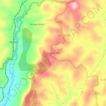
Name: Kyanahalli topographic map, elevation, terrain.
Average elevation: 2,982 ft
Minimum elevation: 2,500 ft
Maximum elevation: 3,402 ft
Other topographic maps
Click on a map to view its topography, its elevation and its terrain.
Kadumane
India > Karnataka > Sakaleshapura taluk
Kadumane, Sakaleshapura taluk, Hassan District, Karnataka, India
Average elevation: 3,114 ft
Ichalapura
India > Karnataka > Sakaleshapura taluk
Ichalapura, Sakaleshapura taluk, Hassan District, Karnataka, 573214, India
Average elevation: 3,009 ft
Sakleshpur
India > Karnataka > Sakaleshapura taluk
Sakleshpur, Sakaleshapura taluk, Hassan district, Karnataka, 573134, India
Average elevation: 3,031 ft
Bisle Ghat View Point
India > Karnataka > Sakaleshapura taluk > Arani > Bisale
Bisle Ghat View Point, SH85, Bisale, Arani, Sakaleshapura taluk, Hassan District, Karnataka, 573123, India
Average elevation: 2,103 ft