
Kelso topographic map
Click on the map to display elevation.
About this map
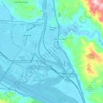
Name: Kelso topographic map, elevation, terrain.
Location: Kelso, Cowlitz County, Washington, 98626, United States (46.08335 -122.92409 46.16644 -122.85728)
Average elevation: 171 ft
Minimum elevation: -16 ft
Maximum elevation: 1,345 ft
Cowlitz County trails, hiking, mountain biking, running and outdoor activities
Other topographic maps
Click on a map to view its topography, its elevation and its terrain.
Toutle River Sediment Retention Structure
United States > Washington > Cowlitz County
Average elevation: 1,138 ft
Toutle River Sediment Retention Structure
United States > Washington > Cowlitz County
Average elevation: 1,138 ft