Geolocate

Krishnanagar topographic map

Click on the map to display elevation.

Krishnanagar

Krishnanagar is located at 23°24′N 88°30′E / 23.4°N 88.5°E / 23.4; 88.5. The area of the municipality is around 16 km2. It is situated on the southern banks of the Jalangi River. It has an average elevation of 14 metres (46 ft). The Tropic of Cancer passes through the outskirts of Krishnanagar. The latitude of the Tropic of Cancer is 23° 26′ 5″ N.

Wikipedia (CC-BY-SA 3.0)

About this map

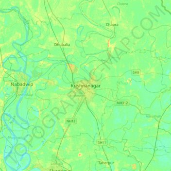
Name: Krishnanagar topographic map, elevation, terrain.

Location: Krishnanagar, Krishnagar-I, Nadia District, West Bengal, 741101, India (23.24585 88.33589 23.56585 88.65589)

Average elevation: 36 ft

Minimum elevation: 10 ft

Maximum elevation: 95 ft

Gear up for your next adventure:

Camping Coffee Makers - Enjoy premium coffee at the summit or campsite
🛡️Insect Repellent - Protection against bugs during outdoor activities
🥘Titanium Cookware - Durable, featherlight pots and pans for backpacking
🧭Compass with Lanyard - Easy‑carry compass for navigation
🏥Hiking First Aid Kits - Comprehensive medical kits for remote trail injuries

As an Amazon Associate, this site earns from qualifying purchases at no extra cost to you.