Geolocate

Khonsa topographic map

Click on the map to display elevation.

Khonsa

Khonsa is located at 27°01′N 95°34′E / 27.02°N 95.57°E / 27.02; 95.57. It has an average elevation of 1215 metres (3986 feet).

Wikipedia (CC-BY-SA 3.0)

About this map

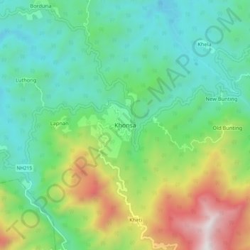
Name: Khonsa topographic map, elevation, terrain.

Location: Khonsa, Khonsa HQ, Tirap, Arunachal Pradesh, 792130, India (26.95101 95.46611 27.03101 95.54611)

Average elevation: 2,815 ft

Minimum elevation: 1,257 ft

Maximum elevation: 6,549 ft

Gear up for your next adventure:

🛶Inflatable Kayak - Portable kayak for rivers, lakes, and expeditions
🚪Portable Camp Chair - Foldable chair for comfort at camp
📱Heavy-Duty Phone Cases - Drop-proof and waterproof protection for outdoor navigation
🗃️Trail First Aid Kit - Essential kit for outdoor injuries and emergencies
📻Weather Alert Radios - Stay informed of storm risks while off-the-grid

As an Amazon Associate, this site earns from qualifying purchases at no extra cost to you.