Geolocate

Ashprington topographic map

Click on the map to display elevation.

👉 Easily get elevation data in JSON, GeoTIFF and KML formats using Elevation API
Thank you for supporting this site ❤️
Make a donation

About this map

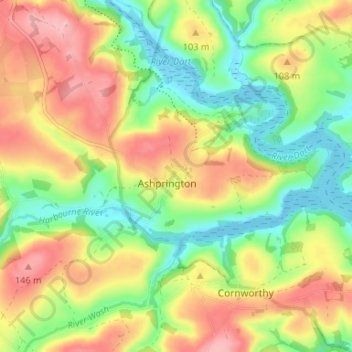
Name: Ashprington topographic map, elevation, terrain.

Location: Ashprington, South Hams, Devon, England, United Kingdom (50.38357 -3.69786 50.42027 -3.63179)

Average elevation: 233 ft

Minimum elevation: -13 ft

Maximum elevation: 512 ft

Other topographic maps

Click on a map to view its topography, its elevation and its terrain.

Penquit

United Kingdom > England > Devon > South Hams > Ermington

Average elevation: 217 ft

Weston

United Kingdom > England > Devon > South Hams > Berry Pomeroy

Average elevation: 194 ft

Gear up for your next adventure:

🦶Carbon Trekking Poles - Reduce knee impact on steep descents with ultra-light poles
🧢Sun Protection Hats - Wide-brimmed and UPF-rated hats for high-altitude sun safety
🥘Titanium Cookware - Durable, featherlight pots and pans for backpacking
🛰️Satellite Messengers - Emergency SOS and two-way messaging for off-grid adventures
🧦Merino Wool Socks - Moisture-wicking, blister-preventing socks for long treks

As an Amazon Associate, this site earns from qualifying purchases at no extra cost to you.