
Pangkalan Kerinci topographic map
Interactive map
Click on the map to display elevation.
About this map
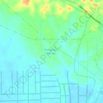
Name: Pangkalan Kerinci topographic map, elevation, terrain.
Average elevation: 46 ft
Minimum elevation: 13 ft
Maximum elevation: 148 ft
Other topographic maps
Click on a map to view its topography, its elevation and its terrain.
Pangkalan Kerinci Kota
Pangkalan Kerinci Kota, Kecamatan Pangkalan Kerinci, Pelalawan, Riau, Sumatra, 28654, Indonesia
Average elevation: 36 ft