Geolocate

Sampaloc topographic map

Click on the map to display elevation.

About this map

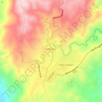
Name: Sampaloc topographic map, elevation, terrain.

Location: Sampaloc, Tanay, Rizal, Calabarzon, 1964, Philippines (14.52621 121.34452 14.56621 121.38452)

Average elevation: 1,293 ft

Minimum elevation: 545 ft

Maximum elevation: 1,821 ft

Other topographic maps

Click on a map to view its topography, its elevation and its terrain.

Tanay River

Philippines > Rizal > Tanay > Little Ville

Average elevation: 112 ft

Gear up for your next adventure:

🧥Men's Rain Shells - Premium waterproof and breathable jackets for mountain weather
🧦Merino Wool Socks - Moisture-wicking, blister-preventing socks for long treks
🛠️Backpacking Tool Kit - Essential toolkit for outdoor repairs
🛡️Insect Repellent - Protection against bugs during outdoor activities
🪶Camp Gear Gift Set - Perfect gift bundle for outdoor fans

As an Amazon Associate, this site earns from qualifying purchases at no extra cost to you.