
Thank you for supporting this site ❤️
Make a donation
Make a donation
Gear up for your next adventure:
As an Amazon Associate, this site earns from qualifying purchases at no extra cost to you.
Além topographic map
Click on the map to display elevation.
Thank you for supporting this site ❤️
Make a donation
Make a donation
Gear up for your next adventure:
As an Amazon Associate, this site earns from qualifying purchases at no extra cost to you.
About this map
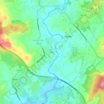
Name: Além topographic map, elevation, terrain.
Location: Além, Sande (Vila Nova), Guimarães, Braga, 4805-273, Portugal (41.44526 -8.36667 41.48526 -8.32667)
Average elevation: 472 ft
Minimum elevation: 312 ft
Maximum elevation: 899 ft
Thank you for supporting this site ❤️
Make a donation
Make a donation
Gear up for your next adventure:
As an Amazon Associate, this site earns from qualifying purchases at no extra cost to you.