Geolocate

Santa Maria topographic map

Click on the map to display elevation.

About this map

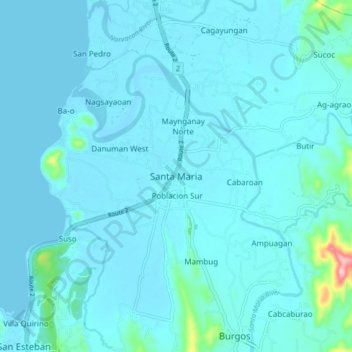
Name: Santa Maria topographic map, elevation, terrain.

Location: Santa Maria, Ilocos Sur, Ilocos Region, 2705, Philippines (17.32986 120.44082 17.40986 120.52082)

Average elevation: 49 ft

Minimum elevation: -3 ft

Maximum elevation: 669 ft

Other topographic maps

Click on a map to view its topography, its elevation and its terrain.

Bessang Pass

Philippines > Ilocos Sur

Average elevation: 4,518 ft

Gear up for your next adventure:

🥘Titanium Cookware - Durable, featherlight pots and pans for backpacking
🪶Camping Sleeping Pad - Comfortable sleeping pad for backpacking
📚USA Hiking Guide Books - Top trail guides and map books
🔊Portable Camp Speaker - Music and alerts at camp
🪶Fire Starter Kit - Reliable fire starter for survival and camping

As an Amazon Associate, this site earns from qualifying purchases at no extra cost to you.