
Make a donation
Gear up for your next adventure:
As an Amazon Associate, this site earns from qualifying purchases at no extra cost to you.
Otisfield topographic map
Click on the map to display elevation.
Make a donation
Gear up for your next adventure:
As an Amazon Associate, this site earns from qualifying purchases at no extra cost to you.
About this map
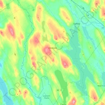
Name: Otisfield topographic map, elevation, terrain.
Location: Otisfield, Oxford County, Maine, 04270, United States (44.00566 -70.61410 44.16866 -70.47842)
Average elevation: 466 ft
Minimum elevation: 249 ft
Maximum elevation: 945 ft
Oxford County trails, hiking, mountain biking, running and outdoor activities
Make a donation
Gear up for your next adventure:
As an Amazon Associate, this site earns from qualifying purchases at no extra cost to you.
Other topographic maps
Click on a map to view its topography, its elevation and its terrain.
Sturtevant Pond
United States > Maine > Oxford County > Magalloway Plantation
Average elevation: 1,332 ft
Mad River Falls
United States > Maine > Oxford County > Batchelders Grant Township
Average elevation: 1,624 ft
Make a donation
Gear up for your next adventure:
As an Amazon Associate, this site earns from qualifying purchases at no extra cost to you.