Geolocate

Reston topographic map

Click on the map to display elevation.

About this map

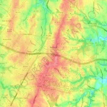
Name: Reston topographic map, elevation, terrain.

Location: Reston, Fairfax County, Virginia, United States (38.90824 -77.39326 38.99833 -77.30887)

Average elevation: 354 ft

Minimum elevation: 167 ft

Maximum elevation: 479 ft

Fairfax County trails, hiking, mountain biking, running and outdoor activities

Other topographic maps

Click on a map to view its topography, its elevation and its terrain.

Difficult Run

United States > Virginia > Fairfax County > Reston

Average elevation: 226 ft

Gear up for your next adventure:

🔊Portable Camp Speaker - Music and alerts at camp
🎒Trail Energy Bars - High‑calorie bars for hiking energy
🎒Trekking Poles - Sturdy poles for balance and stability on rough terrain
💧Water Filtration Bottles - Safely drink from streams and lakes while exploring
👓Polarized Sunglasses - Outdoor sunglasses for glare reduction

As an Amazon Associate, this site earns from qualifying purchases at no extra cost to you.