
Bluff Springs topographic map
Interactive map
Click on the map to display elevation.
About this map
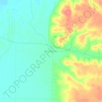
Name: Bluff Springs topographic map, elevation, terrain.
Location: Bluff Springs, Cass County, Illinois, 62622, United States (39.96783 -90.36596 40.00783 -90.32596)
Average elevation: 538 ft
Minimum elevation: 446 ft
Maximum elevation: 689 ft
Other topographic maps
Click on a map to view its topography, its elevation and its terrain.
Arenzville
United States > Illinois > Cass County > Arenzville
Arenzville, Cass County, Illinois, United States
Average elevation: 525 ft
Chandlerville
United States > Illinois > Cass County
Chandlerville, Cass County, Illinois, United States
Average elevation: 482 ft