
East Orleans topographic map
Interactive map
Click on the map to display elevation.
About this map
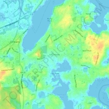
Name: East Orleans topographic map, elevation, terrain.
Average elevation: 33 ft
Minimum elevation: -16 ft
Maximum elevation: 102 ft
Other topographic maps
Click on a map to view its topography, its elevation and its terrain.
Nauset Heights
United States > Massachusetts > Barnstable County > Orleans
Nauset Heights, Orleans, Barnstable County, Massachusetts, 02643, United States
Average elevation: 16 ft