
Concord topographic map
Click on the map to display elevation.
Concord
Concord is located in western Cabarrus County, and has a total area of 60.3 square miles (156.2 km2), of which 0.04 square miles (0.1 km2), or 0.06%, is water. The elevation at the center of downtown is 706 feet (215 m) above sea level.
About this map
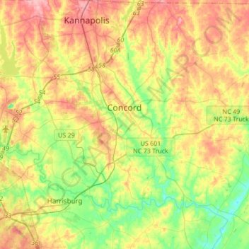
Name: Concord topographic map, elevation, terrain.
Location: Concord, Cabarrus County, North Carolina, United States (35.30540 -80.76506 35.48281 -80.49239)
Average elevation: 659 ft
Minimum elevation: 482 ft
Maximum elevation: 869 ft
Cabarrus County trails, hiking, mountain biking, running and outdoor activities
Other topographic maps
Click on a map to view its topography, its elevation and its terrain.