
Wriezen topographic map
Interactive map
Click on the map to display elevation.
About this map
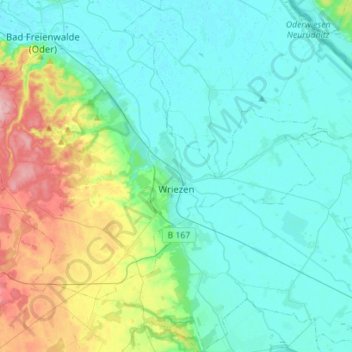
Name: Wriezen topographic map, elevation, terrain.
Location: Wriezen, Märkisch-Oderland, Brandenburg, 16269, Deutschland (52.66362 13.97669 52.78251 14.25710)
Average elevation: 105 ft
Minimum elevation: 0 ft
Maximum elevation: 492 ft
Nachbargemeinden sind im Norden Bad Freienwalde (Oder) und Oderaue, im Osten Neulewin und Neutrebbin sowie im Süden Bliesdorf und Reichenow-Möglin. Westlich grenzen Prötzel, Höhenland und Falkenberg an das Wriezener Stadtgebiet.