
Clima topographic map
Click on the map to display elevation.
About this map
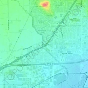
Name: Clima topographic map, elevation, terrain.
Location: Clima, Solano County, California, United States (38.22936 -122.09163 38.26936 -122.05163)
Average elevation: 43 ft
Minimum elevation: 3 ft
Maximum elevation: 200 ft
Solano County trails, hiking, mountain biking, running and outdoor activities
Other topographic maps
Click on a map to view its topography, its elevation and its terrain.
Lagoon Valley & Peña Adobe Park
United States > California > Solano County > Vacaville
Average elevation: 299 ft