
Upper Lambourn topographic map
Interactive map
Click on the map to display elevation.
About this map
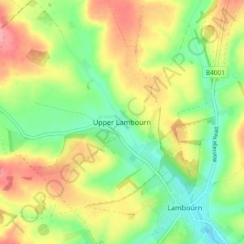
Name: Upper Lambourn topographic map, elevation, terrain.
Average elevation: 538 ft
Minimum elevation: 400 ft
Maximum elevation: 699 ft
Other topographic maps
Click on a map to view its topography, its elevation and its terrain.
Newbury
Royaume-Uni > Angleterre > West Berkshire
Newbury, West Berkshire, Angleterre, Royaume-Uni
Average elevation: 318 ft
Sheffield Bottom
Royaume-Uni > Angleterre > West Berkshire > Sheffield Bottom
Sheffield Bottom, Burghfield, West Berkshire, South East England, Angleterre, Royaume-Uni
Average elevation: 187 ft