
Make a donation
Gear up for your next adventure:
As an Amazon Associate, this site earns from qualifying purchases at no extra cost to you.
Falls Creek topographic map
Click on the map to display elevation.
Make a donation
Gear up for your next adventure:
As an Amazon Associate, this site earns from qualifying purchases at no extra cost to you.
About this map
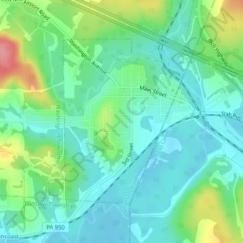
Name: Falls Creek topographic map, elevation, terrain.
Average elevation: 1,460 ft
Minimum elevation: 1,371 ft
Maximum elevation: 1,686 ft
Jefferson County trails, hiking, mountain biking, running and outdoor activities
Make a donation
Gear up for your next adventure:
As an Amazon Associate, this site earns from qualifying purchases at no extra cost to you.
Other topographic maps
Click on a map to view its topography, its elevation and its terrain.
Coolspring
United States > Pennsylvania > Jefferson County > Oliver Township
Average elevation: 1,490 ft
Sandy Valley
United States > Pennsylvania > Jefferson County > Winslow Township
Average elevation: 1,644 ft
Coal Glen
United States > Pennsylvania > Jefferson County > Washington Township
Average elevation: 1,716 ft
Make a donation
Gear up for your next adventure:
As an Amazon Associate, this site earns from qualifying purchases at no extra cost to you.
Green Valley
United States > Pennsylvania > Jefferson County > Knox Township
Average elevation: 1,647 ft