
Udaipur topographic map
Click on the map to display elevation.
Udaipur
Udaipur is located at 24°31′30″N 73°40′38″E / 24.525049°N 73.677116°E / 24.525049; 73.677116. The city covers an area of 64 km2 (25 sq mi) and lies at an altitude of 598.00 m (1,962 ft) above sea level. It is located in the southern region of Rajasthan, near the Gujarat border. The city lies 403 km (250 mi) southwest of the state capital, Jaipur and 250 km (155 mi) northeast from Ahmedabad.
About this map
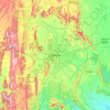
Name: Udaipur topographic map, elevation, terrain.
Location: Udaipur, Girwa Tehsil, Udaipur, Rajasthan, 313001, India (24.41872 73.52626 24.73872 73.84626)
Average elevation: 2,152 ft
Minimum elevation: 1,339 ft
Maximum elevation: 3,501 ft
Other topographic maps
Click on a map to view its topography, its elevation and its terrain.