
Waffenrod topographic map
Interactive map
Click on the map to display elevation.
About this map
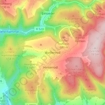
Name: Waffenrod topographic map, elevation, terrain.
Average elevation: 2,106 ft
Minimum elevation: 1,558 ft
Maximum elevation: 2,585 ft
Other topographic maps
Click on a map to view its topography, its elevation and its terrain.
Sachsenbrunn
Deutschland > Thüringen > Landkreis Hildburghausen > Eisfeld
Sachsenbrunn, Eisfeld, Landkreis Hildburghausen, Thüringen, 98678, Deutschland
Average elevation: 2,001 ft
Hinterrod
Deutschland > Thüringen > Landkreis Hildburghausen > Eisfeld
Hinterrod, Eisfeld, Landkreis Hildburghausen, Thüringen, 98666, Deutschland
Average elevation: 2,037 ft