
Thank you for supporting this site ❤️
Make a donation
Make a donation
Gear up for your next adventure:
As an Amazon Associate, this site earns from qualifying purchases at no extra cost to you.
Khe Sanh topographic map
Click on the map to display elevation.
Thank you for supporting this site ❤️
Make a donation
Make a donation
Gear up for your next adventure:
As an Amazon Associate, this site earns from qualifying purchases at no extra cost to you.
About this map
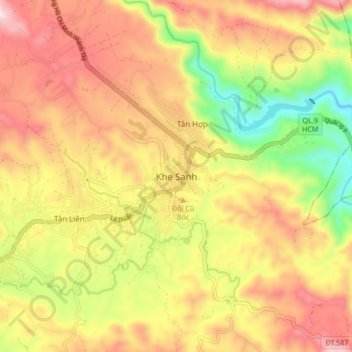
Name: Khe Sanh topographic map, elevation, terrain.
Location: Khe Sanh, Hướng Hóa District, Quang Tri province, Vietnam (16.58959 106.69768 16.66959 106.77768)
Average elevation: 1,266 ft
Minimum elevation: 213 ft
Maximum elevation: 2,185 ft
Thank you for supporting this site ❤️
Make a donation
Make a donation
Gear up for your next adventure:
As an Amazon Associate, this site earns from qualifying purchases at no extra cost to you.