Geolocate

Flemingsburg topographic map

Click on the map to display elevation.

About this map

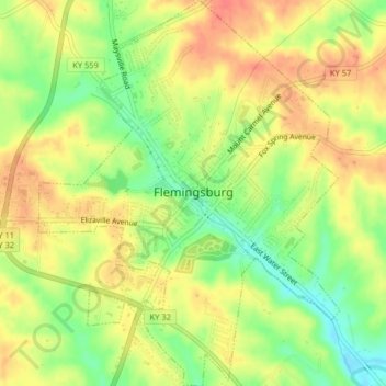
Name: Flemingsburg topographic map, elevation, terrain.

Location: Flemingsburg, Fleming County, Kentucky, United States (38.40638 -83.74998 38.43797 -83.71851)

Average elevation: 879 ft

Minimum elevation: 774 ft

Maximum elevation: 958 ft

Fleming County trails, hiking, mountain biking, running and outdoor activities

Other topographic maps

Click on a map to view its topography, its elevation and its terrain.

Hillsboro

United States > Kentucky > Fleming County

Average elevation: 833 ft

Sherburne

United States > Kentucky > Fleming County

Average elevation: 758 ft

Gear up for your next adventure:

📡Handheld GPS Device - Reliable handheld GPS for outdoor navigation
🔦Compact Flashlight - Reliable flashlight for emergencies
😴Insulated Sleeping Pads - Compact and warm pads for high-elevation camping
🏥Hiking First Aid Kits - Comprehensive medical kits for remote trail injuries
🔭Compact Binoculars - HD vision for scouting terrain and identifying distant landmarks

As an Amazon Associate, this site earns from qualifying purchases at no extra cost to you.