
Thank you for supporting this site ❤️
Make a donation
Make a donation
Gear up for your next adventure:
As an Amazon Associate, this site earns from qualifying purchases at no extra cost to you.
Castelvecchio topographic map
Click on the map to display elevation.
Thank you for supporting this site ❤️
Make a donation
Make a donation
Gear up for your next adventure:
As an Amazon Associate, this site earns from qualifying purchases at no extra cost to you.
About this map
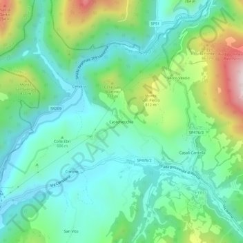
Name: Castelvecchio topographic map, elevation, terrain.
Location: Castelvecchio, Preci, Perugia, Umbria, 06047, Italy (42.87087 13.00096 42.91087 13.04096)
Average elevation: 2,054 ft
Minimum elevation: 1,476 ft
Maximum elevation: 3,593 ft
Thank you for supporting this site ❤️
Make a donation
Make a donation
Gear up for your next adventure:
As an Amazon Associate, this site earns from qualifying purchases at no extra cost to you.