
Make a donation
Gear up for your next adventure:
As an Amazon Associate, this site earns from qualifying purchases at no extra cost to you.
Spartansburg topographic map
Click on the map to display elevation.
Make a donation
Gear up for your next adventure:
As an Amazon Associate, this site earns from qualifying purchases at no extra cost to you.
Spartansburg
Spartansburg Borough is located on the glaciated plateau of northwestern Pennsylvania. The borough is drained by East Branch Oil Creek, which begins at the outlet of Clear Lake, an impoundment of Patrick Run and Stranahan Run. The lowest elevation in Spartansburg is 1,430 ft (440 m) where East Branch Oil Creek flows south out of the borough. The highest elevation is 1,640 ft (500 m) at the southeastern corner of the borough.
Make a donation
Gear up for your next adventure:
As an Amazon Associate, this site earns from qualifying purchases at no extra cost to you.
About this map
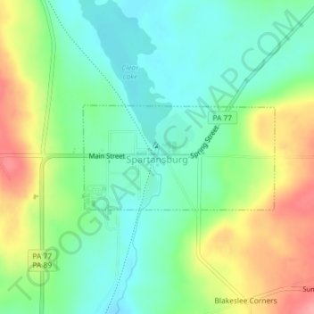
Name: Spartansburg topographic map, elevation, terrain.
Location: Spartansburg, Crawford County, Pennsylvania, United States (41.81954 -79.69392 41.82855 -79.67178)
Average elevation: 1,519 ft
Minimum elevation: 1,404 ft
Maximum elevation: 1,719 ft
Crawford County trails, hiking, mountain biking, running and outdoor activities
Make a donation
Gear up for your next adventure:
As an Amazon Associate, this site earns from qualifying purchases at no extra cost to you.
Other topographic maps
Click on a map to view its topography, its elevation and its terrain.
Teepleville
United States > Pennsylvania > Crawford County > Richmond Township
Average elevation: 1,266 ft
Franklin Pike Corners
United States > Pennsylvania > Crawford County > West Mead Township
Average elevation: 1,237 ft
Make a donation
Gear up for your next adventure:
As an Amazon Associate, this site earns from qualifying purchases at no extra cost to you.