
Plage Agla topographic map
Interactive map
Click on the map to display elevation.
About this map
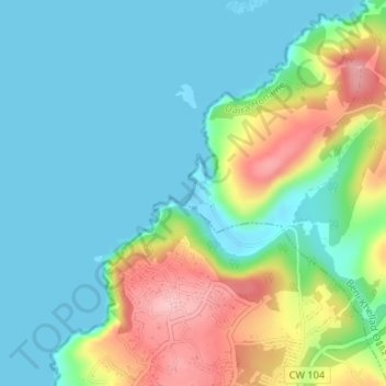
Name: Plage Agla topographic map, elevation, terrain.
Location: Plage Agla, Beni Khellad, Daïra Honaine, Tlemcen, Algérie (35.20458 -1.63788 35.20640 -1.63648)
Average elevation: 154 ft
Minimum elevation: -16 ft
Maximum elevation: 535 ft
Other topographic maps
Click on a map to view its topography, its elevation and its terrain.
Sidi Driss
Algérie > Tlemcen > Daïra Honaine > Beni Khellad > Sidi Driss
Sidi Driss, Beni Khellad, Daïra Honaine, Tlemcen, Algérie
Average elevation: 669 ft