Geolocate

Cockerham topographic map

Click on the map to display elevation.

About this map

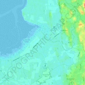
Name: Cockerham topographic map, elevation, terrain.

Location: Cockerham, Lancaster, Lancashire, England, United Kingdom (53.91807 -2.91507 53.98747 -2.79890)

Average elevation: 26 ft

Minimum elevation: 0 ft

Maximum elevation: 171 ft

Other topographic maps

Click on a map to view its topography, its elevation and its terrain.

Heysham

United Kingdom > England > Lancashire > Lancaster

Average elevation: 13 ft

Galgate

United Kingdom > England > Lancashire > Lancaster > Galgate

Average elevation: 141 ft

Thorn Hill

United Kingdom > England > Lancashire > Lancaster

Average elevation: 883 ft

Gear up for your next adventure:

🥩Freeze-Dried Meals - Nutritious and lightweight food for remote expeditions
🪶Compact Camp Shovel - Folding shovel for campsite tasks
🚑Emergency Bivvies - Heat-reflective sleeping bags for survival situations
🎒Day Hiking Backpack - Lightweight backpack perfect for day trips and outdoor adventures
🧭Orienteering Set - Complete compass and map reading kit

As an Amazon Associate, this site earns from qualifying purchases at no extra cost to you.