Geolocate

Indian Head topographic map

Click on the map to display elevation.

About this map

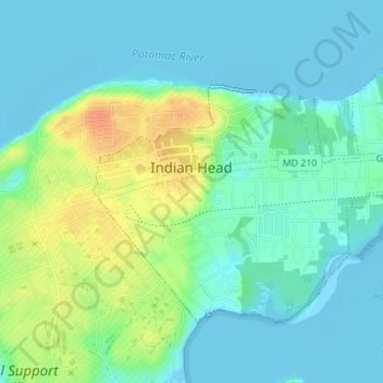
Name: Indian Head topographic map, elevation, terrain.

Location: Indian Head, Charles County, Maryland, United States (38.58951 -77.17111 38.60823 -77.13708)

Average elevation: 39 ft

Minimum elevation: -13 ft

Maximum elevation: 135 ft

Charles County trails, hiking, mountain biking, running and outdoor activities

Other topographic maps

Click on a map to view its topography, its elevation and its terrain.

Clarks Run

United States > Maryland > Charles County > La Plata

Average elevation: 161 ft

White Plains

United States > Maryland > Charles County

Average elevation: 200 ft

Ballentrae

United States > Maryland > Charles County > Waldorf

Average elevation: 207 ft

Hickory Ridge

United States > Maryland > Charles County > La Plata

Average elevation: 174 ft

Doncaster

United States > Maryland > Charles County

Average elevation: 115 ft

Maxwell Hall

United States > Maryland > Charles County > Benedict

Average elevation: 43 ft

Ryceville

United States > Maryland > Charles County > Ryceville

Average elevation: 151 ft

Delight

United States > Maryland > Charles County > Waldorf

Average elevation: 200 ft

Gear up for your next adventure:

🧭Pro Hiking Compasses - High-accuracy liquid-filled compasses for topographic orientation
🛠️Backpacking Tool Kit - Essential toolkit for outdoor repairs
🥇GPS Hiking Watch - Multi‑sport GPS watch with navigation and trail tracking
🛡️Bear Spray Outdoor - Protection in bear country hikes
🪑Portable Camp Table - Compact table for campsite meals

As an Amazon Associate, this site earns from qualifying purchases at no extra cost to you.