
Nielim topographic map
Interactive map
Click on the map to display elevation.
About this map
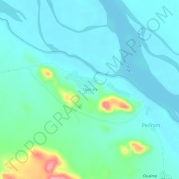
Name: Nielim topographic map, elevation, terrain.
Location: Nielim, Moyen-Chari, Tchad (9.68072 17.79433 9.72072 17.83433)
Average elevation: 1,214 ft
Minimum elevation: 1,135 ft
Maximum elevation: 1,562 ft
Other topographic maps
Click on a map to view its topography, its elevation and its terrain.
Lac Iro
Tchad > Moyen-Chari > Campement Pêcheur Borno
Lac Iro, Campement Pêcheur Borno, Moyen-Chari, Tchad
Average elevation: 1,273 ft
Ndagui Mono UBH 1
Tchad > Moyen-Chari > Ndagui Mono UBH 1
Ndagui Mono UBH 1, Moyen-Chari, Tchad
Average elevation: 1,243 ft