
Make a donation
Gear up for your next adventure:
As an Amazon Associate, this site earns from qualifying purchases at no extra cost to you.
Curaçao topographic map
Click on the map to display elevation.
Make a donation
Gear up for your next adventure:
As an Amazon Associate, this site earns from qualifying purchases at no extra cost to you.
Curaçao
Curaçao, as well as the rest of the ABC islands and Trinidad and Tobago, lies on the continental shelf of South America. It is a thin island with a generally hilly topography; the highest point is Christoffelberg in the northwest, with a peak at 372 m (1,220 ft) above sea level. The coastline's bays, inlets and hot springs offer a source of natural minerals, thermal conditions, and seawater used in hydrotherapy and mesotherapy, making the island one of many balneoclimateric areas in the region. Off the southeast coast lies the small, flat island of Klein Curaçao.
Make a donation
Gear up for your next adventure:
As an Amazon Associate, this site earns from qualifying purchases at no extra cost to you.
About this map
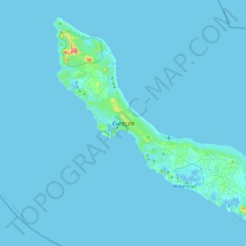
Name: Curaçao topographic map, elevation, terrain.
Location: Curaçao, Curacao, Netherlands (12.03427 -69.16271 12.39273 -68.73664)
Average elevation: 23 ft
Minimum elevation: -3 ft
Maximum elevation: 1,056 ft
Make a donation
Gear up for your next adventure:
As an Amazon Associate, this site earns from qualifying purchases at no extra cost to you.
Other topographic maps
Click on a map to view its topography, its elevation and its terrain.