Geolocate

Monte Emilius topographic map

Click on the map to display elevation.

About this map

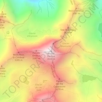
Name: Monte Emilius topographic map, elevation, terrain.

Location: Monte Emilius, Pollein, Aosta Valley, Italy (45.67881 7.38487 45.67891 7.38497)

Average elevation: 9,567 ft

Minimum elevation: 7,188 ft

Maximum elevation: 11,614 ft

Gear up for your next adventure:

📚Navigation Handbooks - Master the art of reading topographic maps and using a compass
🗺️NatGeo Topo Maps - High-quality waterproof printed topographic maps of US Parks
🎒Trail Energy Bars - High‑calorie bars for hiking energy
🧤Tactile Hiking Gloves - Keep hands warm while operating GPS and smartphone screens
📡Handheld GPS Device - Reliable handheld GPS for outdoor navigation

As an Amazon Associate, this site earns from qualifying purchases at no extra cost to you.