
Zacapa topographic map
Interactive map
Click on the map to display elevation.
About this map
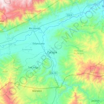
Name: Zacapa topographic map, elevation, terrain.
Location: Zacapa, 1901, Guatemala (14.85461 -89.64940 15.08427 -89.31689)
Average elevation: 1,982 ft
Minimum elevation: 367 ft
Maximum elevation: 7,024 ft
Other topographic maps
Click on a map to view its topography, its elevation and its terrain.