
Maschen topographic map
Interactive map
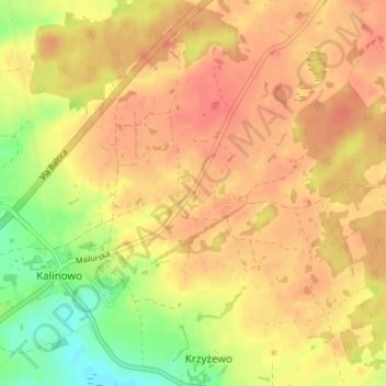
Click on the map to display elevation.
About this map
Name: Maschen topographic map, elevation, terrain.
Average elevation: 545 ft
Minimum elevation: 430 ft
Maximum elevation: 607 ft
Zum 27. Mai 1874 wurde im Zuge einer preußischen Gemeindereform der Amtsbezirk Kallinowen (polnisch Kalinowo) gebildet, der die Gemeinden Alt Czymochen (1929 bis 1945: Finsterwalde), Dorschen, Gingen, Iwaschken (1938 bi 1945: Hansbruch), Kallinowen (1938 bis 1945: Dreimühen), Kokosken (1930 bis 1945: Hennenberg), Kowahlen, Maaschen, Marczynowen (1938 bis 1945: Martinshöhe), Pientken (1938 bis 1945: Blumental) und Trentowsken umfasste.
Other topographic maps
Click on a map to view its topography, its elevation and its terrain.
Auersberg
Polen > Woiwodschaft Ermland-Masuren > powiat ełcki
Auersberg, Gemeinde Dreimühlen, powiat ełcki, Woiwodschaft Ermland-Masuren, 19-311, Polen
Average elevation: 551 ft
Lyck
Polen > Woiwodschaft Ermland-Masuren > powiat ełcki > Lyck
Lyck, powiat ełcki, Woiwodschaft Ermland-Masuren, 19-300, Polen
Average elevation: 423 ft
Seeheim
Polen > Woiwodschaft Ermland-Masuren > powiat ełcki
Seeheim, gmina Prostki, powiat ełcki, Woiwodschaft Ermland-Masuren, 19-335, Polen
Average elevation: 420 ft