
Brighton topographic map
Click on the map to display elevation.
About this map
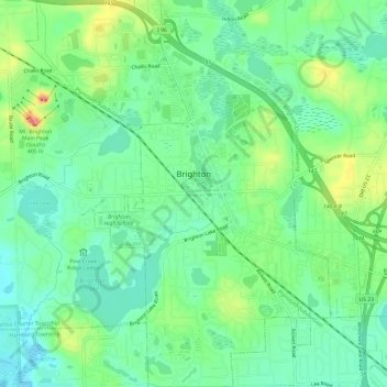
Name: Brighton topographic map, elevation, terrain.
Location: Brighton, Livingston County, Michigan, 48116, United States (42.50734 -83.81074 42.55146 -83.76366)
Average elevation: 942 ft
Minimum elevation: 863 ft
Maximum elevation: 1,102 ft
Livingston County trails, hiking, mountain biking, running and outdoor activities
Other topographic maps
Click on a map to view its topography, its elevation and its terrain.
Green Oak
United States > Michigan > Livingston County > Green Oak Charter Township
Average elevation: 902 ft
Rushton
United States > Michigan > Livingston County > Green Oak Charter Township
Average elevation: 902 ft
Whitmore Lake
United States > Michigan > Livingston County > Green Oak Township > Whitmore Lake
Average elevation: 906 ft