
Wodonga topographic map
Interactive map
Click on the map to display elevation.
About this map
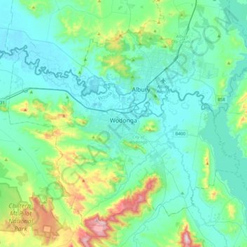
Name: Wodonga topographic map, elevation, terrain.
Location: Wodonga, City of Wodonga, Hume, Victoria, 3690, Australia (-36.28472 146.72826 -35.96472 147.04826)
Average elevation: 856 ft
Minimum elevation: 463 ft
Maximum elevation: 2,671 ft
Other topographic maps
Click on a map to view its topography, its elevation and its terrain.
Wodonga Creek
Australia > Victoria > Wodonga
Wodonga Creek, West Albury, Wodonga, City of Wodonga, Victoria, 3690, Australia
Average elevation: 512 ft
Huon Creek
Australia > Victoria > Wodonga
Huon Creek, Wodonga, City of Wodonga, Victoria, 3690, Australia
Average elevation: 1,122 ft
Baranduda Industrial Estate
Australia > Victoria > Wodonga
Baranduda Industrial Estate, Wodonga, City of Wodonga, Hume, Victoria, 3690, Australia
Average elevation: 574 ft